Mayrhofen - Sport Climbing

Monkey Island climbing area

🅟 Family friendly
🞽
Difficulty
6 - 9
🔹
Route length
8 - 35 m
🍫
Number of routes
50
🞱
Sea Level
900 m
🞂
Exposure
E SE NE
🞀🖈
Best season
Apr - Oct

GPS Position / Ascent
All real-time data of the infrastructures can be found in the fullscreen view of the interactive map
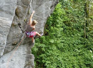
The striking "Jochberg", affectionately referred to in this way in the Zillertal climbing scene, unfolds as a true paradise for climbing enthusiasts and at the same time represents an excellent training area. The uncomplicated accessibility of this place gives Monkey Island an additional fascination that unfolds especially in the evening, when climbing enthusiasts from the region and beyond gather here to conquer the walls and exchange ideas in the picturesque surroundings.

NEW ROUTES:
"Flappi" 6b+, 12m - Challenging slab.
"Buffy" 6a - Intersection climbing - however, the route looks more difficult than it is.
"Cat A Pillar" 7c, 25m - Athletic moves on rope and pincer holds.
"Stubentiger" 7a+, 25m - Very bouldery in the middle section. Afterwards it continues on strong moves. Endurance is required here!
"Soletti Ritter" 6b, 20m - Route with a relentless start
"Soletti Ritter ext." 7b, 30m - From the stance of the route "Soletti Ritter" with a knee clamp (whoever finds it) over the roof, then continue with athletic moves over the second roof.
"La Vita e bella ext." 7c, 35m - From the belaystation of the route Vita straight up over the roof. Continue up the steep pillar to the belaystation.
"Oubliè" 7a, 20m - Steep and very athletic route.

Attention: The climbing area Monkey Island will be closed from 01.10 to 31.03!
🍫
Route overview
level
Quantity
6
5
7
7
8
8
9
30
🅩
Wall inclination
Vertical wall inclination Wall slope overhanging
🞾
Rock
Gneiss
🐲
Walking time approach
15 - 20 min
🞙
Attractiveness
🞙 🞙 🞙 🞙 🞙
🟏
Protection
🞙 🞙 🞙 🞙 🞙
🛬
Access
Follow the asphalt road in the direction of Ginzling. Pass the Mountainsport Base until you see the sign "Klettergebiet Monkey" on the right. There the hiking trail leads steeply uphill. The last section is secured with fixed ropes.
🕞
Public transport
The area is difficult to reach by public transport. There is no official bus stop nearby.
🞞
Journey
From Mayrhofen via the gorge route in the direction of Ginzling. Park next to the road at the Finkenberg turn-off.
🐈
Parking
At the Finkenberg junction, there are parking facilities directly on the main road on the right and left.