E-Bike & Climbers -
Innsbruck region
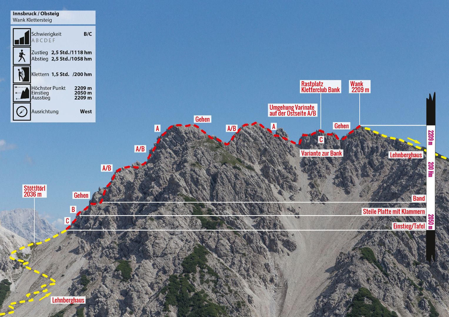
E-Bike & Hike - Via ferrata Wank
State
Locked until cancelled!
Difficulty
B / C
Via Ferata height
200 hm
Sea Level
1150
-
2209 m
Exposure
W
Best season
May - Sep
GPS Position / Ascent
All real-time data of the infrastructures can be found in the
fullscreen view of the interactive map
Download GPX
Beautiful, panoramic via ferrata in the Mieminger mountains, which runs mainly along the ridge, and where the approach can be shortened considerably with the help of an e-bike. The via ferrata leads in a varied way over the ridge from Stöttltörl (2,036m) up to Wankspitze (2,209m). All the spikes on the ridge are climbed over. The constant ups and downs require stamina and strength. The combination of a bike tour, a wonderful wild basin between Hölltörl, Grünsteinscharte and Stöttltör and a summit with a great view makes this route a worthwhile tour.
Climbing time
1:30 h
Walking time descent
1 h
Altitude metres Bike
403 hm
Bike route length
3.5 km
Altitude metres Hike
482 hm
Hike route length
2.6 km
Altitude metres Bike & Hike
1058 hm
Bike & Hike route length
6.1 km
Approach Bike & Hike
Starting at the Arzkasten Inn, the tour begins with the e-bike through the Lehnberg valley along the forest road to the Lehnberghaus. From the Lehnberghaus, continue on foot straight into the valley, first on the forest road and then on a path following the signs in the direction of Stöttltörl. Access time from Lehnberghaus approx. 1 hour.
End point bike / starting point hike
Lehnberghaus (1.554m)
Descent
From the summit of the Wankspitze, an easy trail leads down to the Lehnberghaus (approx. 650 hm.). From here back to the Arzkasten car park by e-bike.
Public transport
You reach the starting point via the Inn Valley. At Telfs or Mötz, drive onto the Mieminger Plateau and continue through the village of Obsteig. After approx. 500 m turn right onto a forest road. After a few minutes' drive you will reach the Arzkasten car park, for which a charge is made. Bus 350 or 355 - stop "Obsteig Holzleiten" (approx. 30 minutes' walk to the starting point at Arzkasten) www.vvt.at
Journey
You reach the starting point via the Inn Valley. At Telfs or Mötz, drive onto the Mieminger Plateau and continue through the village of Obsteig. After approx. 500 m turn right onto a forest road. After a few minutes' drive you will reach the Arzkasten car park, for which a charge is made. Bus 350 or 355 - stop "Obsteig Holzleiten" (approx. 30 minutes' walk to the starting point at Arzkasten) www.vvt.at
Parking
Car park Arzkasten chargeable
Legend:
🄷Bike
👶
🛬Hike
easy
medium
difficult
Singletrail